Sector Model: Urban Growth & Development Explained
The sector model, a key contribution of economist Homer Hoyt, offers a dynamic perspective on urban expansion that contrasts with earlier, more static theories. The theory posits that cities develop in wedge-shaped patterns, or sectors, radiating outward from the Central Business District (CBD) along transportation routes. This model challenges the concentric zone model of urban structure, providing a more nuanced understanding of how different land uses and socioeconomic groups arrange themselves within the urban environment. Recognizing the limitations of the concentric zone model in explaining actual urban development, Hoyt's sector model emphasizes the impact of transportation corridors, like railways and highways, on residential and industrial growth patterns.
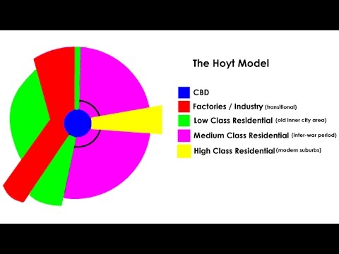
Image taken from the YouTube channel Geographer Online , from the video titled Land Use Model - Hoyt (Geography) .
Urban models serve as essential analytical tools for deciphering the intricate patterns of city growth and organization. These models provide frameworks to understand the spatial distribution of various urban elements.
They help us explain how cities function and evolve over time. By abstracting the complexity of urban environments, models offer simplified representations that highlight key drivers and relationships.
The Sector Model: A Refinement of Urban Understanding
Among these models, the Sector Model stands out as a significant contribution to urban geography and planning. Developed by economist Homer Hoyt in 1939, it offers a distinct perspective on how cities develop.
Unlike earlier models, the Sector Model emphasizes the importance of transportation corridors and sectoral development. These corridors shape the urban landscape.
Homer Hoyt and the Rise of the Sector Model
Homer Hoyt's background in real estate economics heavily influenced the model's formulation. His meticulous analysis of residential rental patterns in American cities led to his insights.
Hoyt observed that similar types of land use tend to cluster along sectors that radiate outwards from the city center. This differed sharply from the concentric ring patterns suggested by earlier theories.
Thesis: Significance and Limitations
The Sector Model provides valuable insights into urban structure, particularly in cities with well-defined transportation arteries. Its emphasis on accessibility and the directional nature of urban growth offers a crucial refinement to our understanding.
However, the model is not without its limitations. Its applicability varies depending on the city's specific context and historical development.
Furthermore, it should be considered alongside other models. Ernest Burgess's Concentric Zone Model offers a complementary perspective, although with different underlying assumptions.
Therefore, a comprehensive understanding of urban development requires a nuanced approach. This involves integrating multiple theoretical frameworks to account for the complexities of real-world urban environments.
Core Concepts: How the Sector Model Works
Urban models serve as essential analytical tools for deciphering the intricate patterns of city growth and organization. These models provide frameworks to understand the spatial distribution of various urban elements.
They help us explain how cities function and evolve over time. By abstracting the complexity of urban environments, models offer simplified representations.
These simplified representations are useful for identifying key drivers of urban form. The Sector Model, proposed by Homer Hoyt, offers a unique perspective on this urban landscape.
It departs from earlier concentric zone theories by emphasizing the role of transportation corridors and sectoral development. Understanding the core concepts of this model is crucial for appreciating its contributions and limitations.
Central Tenets of the Sector Model
The Sector Model is underpinned by several fundamental principles that differentiate it from other urban models. These tenets explain how cities grow and how different areas are influenced by specific factors.
Let's delve into these key aspects:
Urban Growth Radiates Outwards Along Sectors
Unlike the concentric zone model, which posits that cities expand in rings, the Sector Model suggests that urban growth extends outwards from the city center along specific pathways or sectors. These sectors are often determined by transportation routes, geographical features, or even pre-existing development patterns.
As a city expands, these sectors stretch outwards, influencing land use and property values along their path. This means that similar types of land use tend to cluster together.
They form wedge-shaped sections extending from the city center to the periphery.
High-Rent Residential Areas Drive the Location of Other Sectors
A key element of the Sector Model is the idea that high-rent residential areas exert a significant influence on the location and development of other urban sectors. Hoyt argued that the presence of affluent neighborhoods tends to attract commercial and industrial activities that cater to the needs and preferences of the residents in these areas.
This is because businesses and services want to be close to their target market.
They also aim to benefit from the economic activity generated by wealthy residents. Consequently, we see a gravitation towards high-rent sectors.
Land Use is Heavily Influenced by Transportation and Accessibility
Perhaps one of the most enduring contributions of the Sector Model is its emphasis on the role of transportation and accessibility in shaping urban form. Hoyt recognized that ease of movement and access to key locations are critical determinants of land use patterns and property values.
Sectors tend to develop along major transportation corridors, such as highways, railroads, and waterways. This is because businesses and residents seek to maximize their accessibility to other parts of the city and beyond.
Key Concepts Within the Model
To fully grasp the Sector Model, it's important to understand the key concepts that define its structure and dynamics. These concepts shed light on how different zones form and interact within the urban environment:
Residential Zones: Formation of High and Low-Rent Areas in Sectors
The Sector Model posits that residential areas are not uniformly distributed in concentric rings, as the Concentric Zone Model suggests. Instead, they form sectors based on rent-paying ability.
High-rent areas tend to cluster together, extending outwards from the city center along desirable transportation routes or geographical features.
Low-rent areas, conversely, tend to be located in less desirable sectors, often adjacent to industrial or commercial zones. The spatial arrangement of these residential sectors is a key feature of the Sector Model.
Industrial Zones: Development Along Transportation Routes
Industrial zones, according to the Sector Model, are strongly linked to transportation corridors. Industries require efficient access to raw materials, labor, and markets.
They also tend to locate along major transportation routes, such as highways, railroads, and waterways. This allows for the easy movement of goods and people.
These zones often form distinct sectors that extend outwards from the city center, influencing the surrounding land uses and property values.
Commercial Zones: Alignment with Residential and Industrial Sectors
Commercial zones, encompassing retail, offices, and services, align with residential and industrial sectors.
Commercial activities tend to locate in areas accessible to both residential populations and industrial areas. This alignment is crucial for businesses to thrive and for residents and workers to access goods and services.
The configuration of commercial zones reflects the sectoral structure of the city.
Real Estate Values: The Underlying Basis of the Model
At the heart of the Sector Model lies the concept of real estate values. Hoyt, as a real estate economist, emphasized that property values are the fundamental driving force behind urban development patterns.
High-value properties attract businesses and services, while low-value properties may be associated with industrial or lower-income residential areas.
The interplay of these forces shapes the sectors.
Understanding the dynamics of real estate values is essential for applying and interpreting the Sector Model effectively.
Historical Roots: The Genesis of the Sector Model
Urban models serve as essential analytical tools for deciphering the intricate patterns of city growth and organization. These models provide frameworks to understand the spatial distribution of various urban elements.
They help us explain how cities function and evolve over time. By abstracting the complex reality of urban environments, urban models allow us to develop a clearer understanding of the key processes that drive urban development.
The Sector Model, like other urban models, has a story of its own, rooted in the specific historical and intellectual context in which it was developed. It’s important to understand this background to appreciate both the model's contributions and its limitations.
This section delves into the genesis of Homer Hoyt’s Sector Model, examining the forces that shaped its creation.
Homer Hoyt: A Pioneer in Real Estate and Urban Analysis
Understanding the Sector Model requires an appreciation of Homer Hoyt's background and the context in which he worked. Hoyt wasn’t just an academic theorizing about cities.
He was a practical real estate economist deeply involved in analyzing urban land values and housing markets.
Biography and Background
Homer Hoyt (1895-1984) was a prominent American land economist and real estate appraiser. His career spanned several decades, during which he held positions in both the public and private sectors.
He worked for the Federal Housing Administration (FHA) during the New Deal era. This gave him access to an unprecedented amount of data on housing markets across the United States.
Hoyt was also involved in real estate consulting, advising developers and investors on market trends and property values. This blend of academic rigor and practical experience informed his approach to urban analysis.
The Motivation Behind the Sector Model
Hoyt's motivation for developing the Sector Model stemmed from his dissatisfaction with existing urban models, particularly the Concentric Zone Model proposed by Ernest Burgess. While Burgess’s model provided a useful initial framework, Hoyt believed it oversimplified the complexities of urban spatial structure.
Hoyt observed that cities didn't grow in neat, concentric circles. Instead, growth was often channeled along transportation routes and influenced by the location of high-rent residential areas.
He sought to create a model that better reflected the influence of these factors on urban development and land values. Hoyt recognized that real estate values were not uniformly distributed across a city. Instead, they clustered along corridors extending outward from the city center.
The Sector Model was thus conceived as a more realistic representation of urban spatial patterns, one that emphasized the importance of transportation and accessibility in shaping urban form.
Chicago: The Living Laboratory
Chicago, Illinois, served as a crucial case study in Hoyt’s development of the Sector Model. The city's unique urban form and rapid growth during the early 20th century provided a rich source of empirical evidence for his research.
Chicago as a Context for the Model
Chicago's history as a major transportation hub, with its extensive network of railroads and waterways, made it an ideal place to observe the sectoral patterns of urban development.
The city's early industrial growth was concentrated along transportation corridors, shaping the distribution of residential and commercial areas. This was because it has an industrial land use and major transport infrastructure.
The real estate market in Chicago was also highly competitive and dynamic, providing Hoyt with valuable data on land values and housing preferences.
Sectoral Development in Chicago: Examples
Hoyt observed that high-rent residential areas in Chicago tended to cluster along certain corridors extending outward from the city center, such as the North Shore along Lake Michigan.
These high-rent sectors attracted commercial and service industries, further reinforcing the sectoral pattern. Industrial areas, meanwhile, developed along railroad lines and waterways, creating distinct industrial sectors within the city.
These observations of Chicago's urban form led Hoyt to formulate the key principles of the Sector Model, emphasizing the role of transportation, accessibility, and high-rent residential areas in shaping urban spatial structure. The specific examples from Chicago helped him illustrate and validate his model.
Real-World Applications: Where the Sector Model Shines
Historical Roots: The Genesis of the Sector Model Urban models serve as essential analytical tools for deciphering the intricate patterns of city growth and organization. These models provide frameworks to understand the spatial distribution of various urban elements. They help us explain how cities function and evolve over time. By abstracting the Sector Model, it's time to examine the true-to-life application of the Sector Model.
In practice, the Sector Model's utility is most pronounced in cities exhibiting particular characteristics and developmental patterns. Identifying these conditions allows us to appreciate the model's relevance in urban analysis.
Cities with Strong Transportation Corridors
The Sector Model's core premise revolves around the influence of transportation arteries on urban development. Cities with well-defined transportation networks—such as major highways, rail lines, or waterways—tend to exhibit sectoral patterns more prominently.
The accessibility and connectivity offered by these corridors shape the spatial distribution of residential, commercial, and industrial zones. For example, industrial sectors often emerge along railway lines to facilitate the efficient movement of goods, while high-income residential areas extend along desirable transportation routes that offer convenient access to employment centers and amenities.
Transportation Costs and Land Use
The Sector Model posits that land use is significantly affected by transportation costs and accessibility. Cities where the cost of commuting plays a substantial role in residential and business location decisions tend to align with the model's predictions.
Areas with lower transportation costs, often located closer to major transportation routes, attract economic activities and residential development. Conversely, areas with higher transportation costs may experience slower growth or be relegated to less desirable land uses. This dynamic underscores the interplay between transportation infrastructure and urban spatial structure.
Applicability in Major U.S. Cities
Historically, the Sector Model has found considerable applicability in analyzing urban development patterns in major cities across the United States. The model's emphasis on transportation corridors and its focus on the outward expansion of urban areas resonate with the developmental trajectories of many American metropolises.
Chicago, the city that significantly influenced Hoyt's model, remains a compelling example. The city's radial transportation network and the sectoral distribution of residential and industrial areas provide empirical support for the model's validity. Other cities with similar characteristics, such as Atlanta, Houston, and Dallas, may also exhibit patterns consistent with the Sector Model.
Practical Applications in Urban Development
Beyond its theoretical underpinnings, the Sector Model serves as a valuable tool for urban planners and geographers in a variety of practical applications. It provides a framework for understanding and addressing urban challenges.
Informing Urban Planning and Policy
Urban planners utilize the Sector Model to inform land-use planning, transportation infrastructure development, and housing policy. By understanding the spatial distribution of different urban elements, planners can make informed decisions about zoning regulations, infrastructure investments, and affordable housing initiatives.
For example, the model can guide the placement of new residential developments to ensure access to transportation corridors and employment centers. It can also inform the design of transportation networks to promote efficient movement within the city and reduce congestion.
Supporting Geographic Analysis
Geographers employ the Sector Model to analyze urban spatial patterns, identify trends in urban development, and assess the impact of transportation infrastructure on land use. The model serves as a framework for conducting spatial analysis, mapping urban characteristics, and evaluating the effectiveness of urban policies.
By applying the Sector Model, geographers can gain insights into the dynamics of urban growth, the distribution of resources, and the social and economic inequalities that may arise as a result of uneven development. This spatial perspective is crucial for understanding the complexities of urban environments and promoting equitable and sustainable urban development.
Strengths and Weaknesses: A Balanced Perspective
Urban models serve as essential analytical tools for deciphering the intricate patterns of city growth and organization. These models provide frameworks to understand the spatial distribution of various urban elements. They help us explain how cities evolve. However, each model operates under specific assumptions and is subject to limitations. The Sector Model, while offering valuable insights, is no exception. A balanced assessment requires acknowledging both its contributions and shortcomings in interpreting urban landscapes.
Advantages of the Sector Model
The Sector Model presents several key improvements over earlier urban models, particularly the Concentric Zone Model. Its emphasis on transportation infrastructure and sectoral development patterns provides a more nuanced understanding of urban form.
Rectifying the Concentric Zone Model
The Concentric Zone Model, proposed by Ernest Burgess, envisioned cities as a series of concentric rings radiating from the central business district (CBD). While groundbreaking in its time, this model often failed to account for the irregular shapes and uneven growth patterns observed in many cities.
The Sector Model addressed this limitation by recognizing that urban growth tends to occur in wedges or sectors, influenced by factors like transportation routes and geographic features. This departure from a purely concentric pattern allowed for a more realistic representation of urban spatial dynamics.
The Primacy of Transportation Corridors
One of the Sector Model's most significant contributions is its recognition of the crucial role that transportation corridors play in shaping urban development. Hoyt argued that high-rent residential areas tend to expand outwards along major transportation routes, attracting commercial and industrial activities along these same corridors.
This emphasis on transportation networks highlighted the importance of accessibility and connectivity in determining land use patterns. It also acknowledges the influence of infrastructure investments on urban growth, a factor often overlooked in earlier models.
Limitations and Criticisms of the Sector Model
Despite its strengths, the Sector Model is not without its limitations. Its relative simplicity can lead to over-generalizations. It can also lead to a neglect of other important factors that influence urban structure.
Oversimplification of Urban Structure
While the Sector Model offers a more refined perspective than the Concentric Zone Model, it can still oversimplify the complex realities of urban landscapes. Cities are influenced by a multitude of factors. These factors include historical development, economic forces, social dynamics, and political decisions.
The model's focus on a limited number of sectors may fail to capture the intricate mosaic of land uses and social patterns found in many urban areas. The model may not adequately account for the influence of local neighborhood characteristics and community-based planning initiatives.
Applicability in Polycentric Cities
The Sector Model is most applicable to cities with a dominant central business district and well-defined transportation corridors radiating outwards. However, many modern cities have evolved into polycentric urban regions, with multiple centers of economic and social activity.
In these polycentric cities, the Sector Model's assumptions about a single, dominant CBD and radial growth patterns may not hold true. The model may struggle to explain the complex interactions between multiple urban centers and the diverse patterns of land use and transportation that characterize these regions.
Model Comparisons: Contextualizing the Sector Model
Urban models serve as essential analytical tools for deciphering the intricate patterns of city growth and organization. These models provide frameworks to understand the spatial distribution of various urban elements. They help us explain how cities evolve. However, each model operates under specific assumptions and offers unique insights. To fully appreciate the Sector Model's value, it is essential to compare it with other prominent urban models, such as the Concentric Zone Model and the Multiple Nuclei Model.
Sector vs. Concentric: Addressing Limitations
The Concentric Zone Model, developed by Ernest Burgess, proposes that cities grow outward from a central business district (CBD) in a series of concentric rings. These rings represent different land uses and socioeconomic characteristics, with the innermost rings typically characterized by industry and lower-income housing, and the outermost rings by higher-income residential areas.
While the Concentric Zone Model provided an initial framework for understanding urban structure, it had limitations. One of the most significant criticisms was its assumption of uniform growth in all directions. This assumption failed to account for the influence of transportation routes and other factors that can shape urban development in specific directions.
The Sector Model improves upon the Concentric Zone Model by recognizing that urban growth is not uniform but rather occurs in sectors. These sectors radiate outward from the CBD along major transportation routes, such as railways and highways. The Sector Model emphasizes that certain activities and social groups tend to cluster along these corridors. This is especially true for high-income residential areas, which tend to develop along desirable transportation routes. These routes provide access to employment and amenities.
By acknowledging the influence of transportation corridors and directional growth, the Sector Model offers a more realistic representation of urban development compared to the Concentric Zone Model.
Sector vs. Multiple Nuclei: Polycentric Realities
The Multiple Nuclei Model, developed by Chauncy Harris and Edward Ullman, proposes that cities do not grow from a single central point. Instead, they develop around multiple nuclei or centers of activity. These nuclei may include industrial parks, shopping centers, or universities, each attracting specific types of land uses and activities.
The Multiple Nuclei Model offers a more complex and nuanced understanding of urban structure, particularly in larger, more decentralized cities. Unlike the Sector Model, which primarily focuses on the influence of transportation corridors radiating from a central point, the Multiple Nuclei Model recognizes that cities can have multiple centers of growth and activity.
While the Sector Model highlights the importance of transportation in shaping urban sectors, the Multiple Nuclei Model emphasizes the role of specialized nodes in attracting and organizing urban development. For instance, a large university can create a surrounding area of student housing, bookstores, and restaurants. This is not necessarily tied to a radial transportation route emanating from the city center.
The Sector Model contrasts with the Multiple Nuclei Model by assuming that the CBD remains a dominant force in shaping urban development. The Multiple Nuclei Model, conversely, assumes that other, smaller, nuclei can become more important than the CBD as a city evolves.
In conclusion, the Sector Model, while an improvement over the Concentric Zone Model, offers a different perspective compared to the Multiple Nuclei Model. Understanding the strengths and limitations of each model provides a more comprehensive framework for analyzing and interpreting urban structures.
Modern Relevance and Critiques: The Sector Model Today
Urban models serve as essential analytical tools for deciphering the intricate patterns of city growth and organization. These models provide frameworks to understand the spatial distribution of various urban elements. They help us explain how cities evolve. However, each model operates under specific assumptions and, therefore, possesses limitations. The Sector Model, while influential, is no exception. This section examines the model's continued relevance in the 21st century while acknowledging the criticisms levied against it. We will explore its utility in explaining certain aspects of modern urban development and confront its shortcomings in the face of globalization and evolving urban dynamics.
The Sector Model's Enduring Utility
Despite the emergence of more complex urban forms, the Sector Model retains relevance, particularly in understanding the impact of transportation infrastructure on urban spatial organization. The model's emphasis on corridors of development radiating from the city center continues to hold true in many cities where major highways and rail lines shape land use patterns.
Specifically, the model accurately predicts the clustering of industrial and commercial activities along transportation routes, a phenomenon still observable in many metropolitan areas.
For instance, the development of logistics and distribution centers along major interstates exemplifies the enduring validity of the Sector Model's core principles.
Limitations in a Globalized World
However, the Sector Model's applicability diminishes when confronted with the complexities of globalization and the rise of polycentric urban regions. The model, developed in the context of early 20th-century industrial cities, struggles to account for the dispersed nature of economic activities and residential areas in contemporary metropolitan landscapes.
Globalization has facilitated the decentralization of industries, the proliferation of edge cities, and the emergence of specialized economic clusters outside traditional urban cores. These trends challenge the Sector Model's assumption of a single, dominant central business district.
Furthermore, the model fails to adequately address the influence of non-economic factors, such as social networks, cultural amenities, and environmental considerations, on urban development patterns.
Common Criticisms and Alternative Perspectives
Urban planners and geographers have offered several criticisms of the Sector Model over the years. A primary concern is its over-simplification of urban reality. The model assumes a relatively uniform landscape and overlooks the influence of local factors, such as topography, zoning regulations, and historical contingencies, on urban spatial organization.
Another critique is its limited ability to explain the development of polycentric cities, where multiple nodes of economic activity compete for dominance. In such urban areas, the Sector Model's emphasis on a single, centralized core becomes less relevant.
Furthermore, critics argue that the model fails to account for the role of social and political forces in shaping urban development. Government policies, community activism, and private sector investment decisions can significantly alter land use patterns and defy the Sector Model's predictions.
Moreover, the Sector Model has also been scrutinized for its lack of attention to social equity issues. It does not adequately address how urban spatial organization can perpetuate or exacerbate inequalities in access to housing, employment, and other essential services. Alternative models, such as those incorporating social justice perspectives, offer more nuanced understandings of these dynamics.
In response to these critiques, urban scholars have developed more sophisticated models that incorporate a wider range of factors, including globalization, technological change, and social inequality. These models seek to provide a more comprehensive and nuanced understanding of contemporary urban development.
Video: Sector Model: Urban Growth & Development Explained
![7 Urban Geography City Models You Need To Know [AP Human Geography Unit 6 Topic 5] (6.5)](https://i.ytimg.com/vi/O5bpAw_OS-k/hq720.jpg)
FAQs: Sector Model: Urban Growth & Development Explained
How does the sector model differ from other urban models?
Unlike concentric zone models that emphasize rings, the sector model highlights how urban areas grow along transportation routes. It suggests distinct sectors, like industrial or residential areas, expand outwards from the city center along these corridors.
What influences the shape of the sectors in the sector model?
Transportation networks, such as railroads, highways, and rivers, are key factors. High-income residential areas often develop along desirable routes and away from industrial zones. Lower-income areas may be located near industrial sectors due to accessibility and affordability.
Why does the sector model suggest certain activities cluster?
Similar industries and activities tend to cluster together due to factors like shared infrastructure, access to resources, and skilled labor pools. This clustering strengthens the growth of specific sectors radiating outwards as described in the sector model.
Is the sector model still relevant in modern urban planning?
While the original sector model has limitations, it provides valuable insights into how transportation infrastructure shapes urban growth. Contemporary urban planning often integrates elements of the sector model, considering the interplay of transportation, land use, and socio-economic factors.
So, next time you're driving around a city and notice how the industrial areas seem to hug the railroad tracks while the high-end homes cluster elsewhere, remember the sector model! It's a simple yet insightful way to understand the forces that shape our urban landscapes, even if real-world cities are a little more complex than the diagram.
